| Country | USA |
| Capital city | Helena |
| Area | 380,846 km² |
| Population | 1,085,407 people (2020) |
| Governor | Steve Bullock |
| Time zone | Central: UTC -7/ -6 |
| ZIP code | MT |
| ISO 3166-2 | US-MT |
| Official site | www.mt.gov |
| Montana | |
Montana (in English: Montana) is a state in the USA, whose zip code is MT, and the capital is Helena. Montana has a population of 1,062,305 (2018). It borders Canada. Montana is home to part of the territory of one of the largest tourist attractions in the USA – Yellowstone National Park.
Geography
With an area of 380,846 km², Montana is 3.5 times larger than Bulgaria, slightly larger than Japan (377,944 km²) and slightly smaller than Paraguay (406,752 km²). The state is the fourth largest in area in the USA, surpassed only by Alaska, Texas and California; and the 56th largest administrative unit in the world by area. To the north, Montana has a common border of 872 km with three Canadian provinces: British Columbia, Alberta and Saskatchewan. To the east it borders the states of North Dakota and South Dakota, to the south it shares a common border with Wyoming, and to the west and southwest with Idaho.
Relief
Terrain of Montana
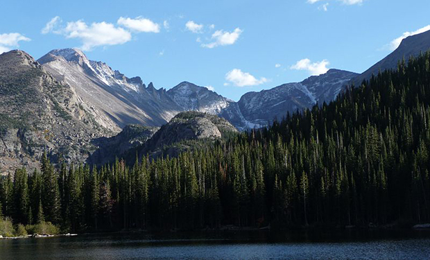
Montana’s relief is diverse, distinctly divided by the Continental Divide, which runs through the state in a northwest-center-south direction, dividing it into two independent geographical parts – east and west. Montana is known for its many mountain ranges in the west, most of which fall under the Rocky Mountain chain. The Absaroka and Burtout ranges in southern Montana fall into the Central Rocky Mountains. About 60% of the state’s territory is occupied by prairie, part of the Great Plains. However, even in the flattest parts of the state there are islets of small mountain ranges, most prominent in central Montana.
The Bitterroot Range, one of the longest continuous ranges in the Rocky Mountain chain, serves as a natural boundary between Idaho and Montana to the west, and the southern portion of the range descends toward the Continental Divide. Between the Bitterroot and the Continental Divide are Cabinet Mountain, the Anaconda Range, the Missions, the Garnet Range, the Flint Creek Range, and the Sapphire Range.
Missouri Breaks
The area where the mountains give way to the prairie is called the Rocky Mountain Front, most prominently the series of low mountains known as the Lewis Range. Glacier National Park is located here. Glacier is home to the geologically significant Triple-Divide-Peak watershed, which is the primary reason the Waterton, Belle and St. Mary rivers turn north toward Alberta, Canada. There they flow into the Saskatchewan River, which in turn flows into Hudson Bay.
East of the Watershed are several nearly parallel mountain ranges: Gravely Range, Tobacco Roots, Madison Range, Gallatin Range, Big Belt, Bridger, Absaroka, and Burtooth. The Burmouth Plateau is the largest land mass with an average elevation of 3,000 m located in the continental United States. The highest point in Montana is also located here – Mount Grenit with a height of 3901 m.
Glacier National Park
Between the mountain ranges there are numerous picturesque valleys used for agricultural needs, tourism and recreation. Among the most famous are the Big Hole, Bitterroot, Gallatin, Flathead and Paradise valleys.
To the east and north of the Rockies Front are the Northern Plains, which are extremely sparsely populated. In this part of the state there are numerous plateaus, representing low, wide and flat mountain massifs, as well as land formations characteristic of this relief, called badlands. They are most clearly visible near the state borders with Wyoming and the two Dakotas, as well as near Saskatchewan and Alberta. To the east of the Watershed are several mountain ranges, including the Castle, Crazy, Little Belt, Snowy, Sweet Grass Hills, Bull, Pryor and Long Pines.
In the center-north are located numerous rocky formations, the most popular of which is the Missouri Breaks. In the same area are located the three most prominent rocky hills (buttes) in the state: Square, Shaw and Crown, which were formed by the erosion caused by the wind. Similar rock formations can be seen throughout the Great Plains states, particularly Colorado. Here are Makoshika and Medicine Rocks National Parks, known for their beautiful badlands.
Numerous fossils have been found in Montana, with the largest number of finds found in the area of the Hell Creek massif.
Leads
There are many rivers in Montana, whose waters are used for domestic needs, irrigation, hydropower, as well as for fishing. Montana is one of the few regions in the world where three watersheds exist at the same time, which is a fact thanks to the Continental Divide.
Gallatin River in winter
The basins’ starting point is Triple-Divide-Pee in Glacier National Park. Montana’s rivers drain into the Pacific Ocean, the Gulf of Mexico, and Hudson Bay.
West of the Watershed flows the Clark Fork, Montana’s largest river by flow, which originates in the Rocky Mountains near the town of Butte. Its main tributaries are the Blackfoot and Bitterroot, which flow into it in the Missoula area, and the Flathead River flows into Idaho. The Clark Fork drains into Lake Pend O’Reilly in Idaho, which feeds the Columbia River, which flows into the Pacific Ocean. The Flathead and Kootenay are the largest flowing rivers in western Montana.
East of the Watershed rises the Missouri, the longest river in North America, which begins its course in the Rocky Mountains, where the Jefferson, Madison, and Gallatin rivers share the same mouth. The Missouri crosses the central part of the state and near the Missouri Breaks it flows into North Dakota. The Yellowstone River, which originates in Yellowstone National Park (in Wyoming), flows north of Livingston, Montana, turns east near Billings, continues straight across the state until it flows into the Missouri near the North Dakota border. The Yellowstone River is the longest undammed river in the United States. Other major tributaries of the Missouri located in Montana are the Milk, Marias, Tongue, and Musselshell. Near Great Falls is the shortest water basin recognized as a river – Roe. Between 1989 and 2006, the river was listed in the Guinness Book of World Records, but after 2006, this category was removed and the river lost its title. All rivers in Montana that flow into the Missouri drain to the Gulf of Mexico via the Mississippi River, the largest tributary of which is the Missouri.
The third catchment includes the Waterton, Belle and St. Mary rivers . They flow in the direction of Alberta, Canada, where they flow into the Saskatchewan River, which in turn flows into Hudson Bay.
In addition to rivers, Montana also has several lakes, the largest of which is Flathead. It is the largest freshwater lake in the western United States. Numerous dams are located along the Missouri, most of which are used to irrigate cultivated areas.
Protected areas
Montana is home to several large national parks. The largest, located entirely on the territory of the state, is Glacier, called the Crown of the Continent. Three of the five entrances to Yellowstone National Park are located in Montana. Other federally recognized sites are Little Bighorn National Battlefield, Bighorn Canyon, Big Hole National Battlefield, Lewis and Clark Rock Cave System, Bison Range National Bison Conservation Area.
Pompeii Pillar National Natural Monument
Montana has ten National Forests and more than 20 nature reserves. The state government administers a total of 150,000 km² of land, of which 1,110 km² are national parks and forests.
The Federal National Park Management System includes:
- Big Hall National Battlefield
- Big Horn National Canyon
- Glacier National Park
- Grant-Course Ranch National Historic Landmark
- Lewis and Clark National Historic Trail
- Little Bighorn National Battlefield
- Nez Perce National Historical Park
- Yellowstone National Park
Climate
Due to the variety of geographic areas in Montana, the state has a variety of climates. Montana stretches from the 45th parallel, which is almost halfway between the North Pole and the equator, to the 49th parallel. The state is located between 610 and 3901 m above sea level. The western part is mainly mountainous, cut by numerous valleys, with a dominant mountain climate. The eastern part consists of plains and low rocky hills, interrupted only by isolated mountain ranges, and the climate varies between inland continental and semi-desert. The Continental Divide runs in a north-south direction through the mountainous part of the state. It prevents the warm air coming from the Pacific Ocean to pass to the east and the cold dry air from the region ofThe Great Lakes to pass to the west. To the west of the watershed, the dominant climate is transitionally Pacific, characterized by mild winters, cold summers, relatively no wind, and a longer ripening period for cultivated crops. In winter, dense fogs and low clouds often form in the valleys.
Snowfall in the mountains
can reach over 30 m
The average daily temperature in January is −2 °C and in July 29.2 °C. Temperatures in different parts of the state vary dramatically. The plains often experience hot and dry weather with record highs of 47 °C. In summer the nights are cool but pleasant. Temperatures naturally decrease with increasing altitude and hot weather, typical of the plains, is completely unknown above 1200 m above sea level. In Montana, snow can fall at any time of the year, but in July and August, even in the mountainous regions, this is almost impossible to happen.
The coldest temperature recorded in Montana is also the coldest temperature recorded in US weather history. On January 20, 1954, −57 °C was measured near Rogers Pass. Even on such cold nights, temperatures vary considerably and in Helena, located only 40 miles from Rogers Pass, only −38 °C was measured on the same night.
The Grinnell Glacier area
receives about 1,700 mm of precipitation annually
Such periods of extremely cold weather last about a week and are caused by cold continental air moving in from Canada. The cold front is well formed and affects the weather almost instantly. When the warm air from the southwest collides with the cold front, the typical Montana warm chunux winds are formed. Moving at an average of between 50 – 75 km/h, these winds can raise temperatures by more than 20 degrees. An example of this phenomenon is the case of January 15, 1972, when an amplitude of a total of 57 degrees (from an initial −48 °C to a final 9 °C) was recorded in the area of the city of Louma within 24 hours.
The Montana average for precipitation is 380 mm, but it varies dramatically in different areas of the state. The mountain ranges block the warm air from the Pacific Ocean, which lingers over the valleys and is the cause of frequent fogs and light rains, which can reach up to 8,810 mm on average annually. On the other hand, the valleys east of the mountains are much drier with average values between 280 – 290 mm. The mountains themselves receive the heaviest rainfall, often up to 2,500 mm per year. An example of this is Grinnell Glacier in Glacier National Park, which has an average annual precipitation of 2700 mm. The driest point in Montana is an area southwest of the town of Belfry, where for the last 16 years only 167 mm of precipitation has fallen. In Montana, heavy snowfall often begins in late September and can last as late as early May. 7600 mm of precipitation can fall in the mountains in one winter, and in the populated areas of the state, snowfall varies between 760 – 1300 mm.
History
A number of indigenous peoples have lived on the territory of present-day Montana for thousands of years. The first settlers from Europe and other parts of the country meet in the south with the Crow tribe, in the southeast with the Cheyenne; in the central part of the state and in the north with picani (blacklegs), assiniboini and atsina; to the west with the Kootenai and Salish (Flathead). The small Penn d’Oreay and Kalispell tribes lived in the Flathead Lake area and the mountains to the west.
Assiniboine family, ca. 1890
The territory of the state east of the Rocky Mountains was part of the Louisiana Purchase of 1803. The subsequent expedition of Lewis and Clark gave a clearer picture of the geography of the state, which in the 1850s became extremely popular after the discovery of solid deposits of gold and copper. On May 26, 1864, Montana was declared a US territory under the name Montana Territory.
In the late 1860s, the Army established several military posts, including Fort Shaw, Camp Cooke, and Fort Smith. For many years, Montana was the scene of hostilities between Native Americans and the US Army, who fought for control of the land.
After the discovery of solid deposits of gold, silver, copper, coal, and later oil, in 1862, Montana became a center of attraction for gold prospectors, miners, traders and entrepreneurs from all over the country. Gold production from 1862 to 1876 reached a remarkable 144 million dollars for those years; during this time silver became an even more valuable find. The largest mine was located near the town of Butte, known for its vast deposits of silver and copper. Considerable deposits of precious metals have also been discovered on the territory of the current state capital, Helena. With the end of the peak mining period in the late 70s of the 18th century, animal husbandry occupied a central place in Montana’s economy .
Cheyenne, ca. 1890
Railroads reached Montana in 1881, as part of the Union Pacific Railroad route from Denver. In 1883 it was included in the Northern Pacific line from Minneapolis to the territory of the present state of Washington. With two important railway routes passing through its territory and actively developing mining of non-ferrous metals, Montana is becoming an industrial center. On November 8, 1889, Montana officially joined the Union, almost simultaneously with South Dakota, North Dakota, and Washington.
The 1909 amendment to the Property Act had a major impact on the settlement of the state. The revision in the act allows a family to own 1.3 km², instead of only 0.6 km² as before. Tens of thousands arrive in Montana lured by the vast vacant acreage and the high purchase prices of wheat, but many find themselves unprepared for the typically peculiar climate, which is characterized by particularly scarce rainfall. The droughts of 1917-1919 resulted in extremely poor harvests, which in turn forced many people to leave the state. Half of the banks in Montana are going bankrupt because of the huge number of mortgage loans that no one can service anymore. The Great Depression that followedfurther compounding an already dire financial situation, driving many of the state’s farmers and miners into bankruptcy.
It wasn’t until the early 1940s that Montana’s economy got back on its feet, and after the promotion of Yellowstone and Glacier National Parks, tourism became the state’s third largest industry. Montana is one of the largest producers of wheat in the country, which is also one of the highest quality and most expensive.
Population
By population, Montana ranks 44th in the US, ahead of Alaska, Wyoming, South Dakota, North Dakota, Vermont and Delaware. As of 2009, the state had a population of 974,989, an increase of 71,696 since 2000. Growth was felt primarily in the seven largest counties, particularly Gallaton, which reported a 32% increase compared to 2000.
Montana entrance sign
The majority of Montana’s population has European roots: German (29.3%), Irish (16.4%), English (13.1%) and Norwegian (10%). About 6% indicated indigenous people as their origin. Like North Dakota and Minnesota, people of Scandinavian origin live mainly in the farming areas located to the north and east. Montana is home to a total of seven Native American reservations that were established for a total of twelve ethnolinguistic groups and are now home to one of the largest Native American communities in the United States. In the western part of the state, known as a mining center, live mostly Americans of European origin (Irish, English, Finns, Eastern Europeans). The first mining towns were established by settlers from Cornwall, Devon and Wales. The capital Helena was also originally a mining camp that quickly became a center of attraction during the Gold Rush. African Americans make up just 0.5% of the state’s population, and people of Asian descent make up about 0.8%, making Montana one of the most racially homogeneous states.
According to data from the last census of 2000, 94.8% of the population over 5 years of age indicated English as their mother tongue.
Religion
Religious affiliation in Montana is as follows:
- Christians – 82%
- Protestants – 55%
- Lutherans – 15%
- Methodists – 8%
- Baptists – 5%
- Presbyterians – 4%
- United Church of Christ – 2%
- Other Protestants – 21%
- Catholics – 24%
- Mormons – 5%
- Protestants – 55%
- other religions – <1%
- non-religious – 18%
Settlements
View from the largest city in Montana – Billings
Cities:
- Anaconda
- Belgrade
- Billings
- Butte
- Great Falls
- Livingston
- Miles City
- Sydney
- Whitefish
- Helena
Towns:
- Stevensville
Counties
Montana consists of 56 counties :
| Counties in Montana by Population (2009) | ||||||
| Place | District | Population | Place | District | Population | |
| 1 | Yellowstone | 144,797 | 29 | It’s raining | 6771 | |
| 2 | Missoula | 108,623 | 30 | Blaine | 6485 | |
| 3 | Gallaton | 90 343 | 31 | Titon | 6088 | |
| 4 | Flathead | 89,624 | 32 | Pondera | 5814 | |
| 5 | Cascade | 82 178 | 33 | Silly | 5167 | |
| 6 | Lewis and Clark | 61,942 | 34 | Tul | 5151 | |
| 7 | Ravalli | 40 431 | 35 | Broadwater | 4793 | |
| 8 | Silver Bow | 32,949 | 36 | He thought | 4600 | |
| 9 | Lake | 28,605 | 37 | Phillips | 3944 | |
| 10 | Lincoln | 18,717 | 38 | Mineral | 3833 | |
| 11 | Hill | 16,632 | 39 | Sweet Grass | 3667 | |
| 12 | Park | 15,941 | 40 | Sheridan | 3243 | |
| 13 | Glacier | 13,550 | 41 | Granite | 2879 | |
| 14 | Big Horn | 13,015 | 42 | Fallon | 2725 | |
| 15 | Jefferson | 11,470 | 43 | Judith Basin | 2051 | |
| 16 | Fergus | 11,208 | 44 | Wheatland | 2044 | |
| 17 | Custer | 11 189 | 45 | Migger | 1908 | |
| 18 | Sanders | 11,098 | 46 | Liberty | 1748 | |
| 19 | Roosevelt | 10,303 | 47 | Daniels | 1703 | |
| 20 | Carbon | 9756 | 48 | Powder River | 1664 | |
| 21 | Richland | 9313 | 49 | McCone | 1624 | |
| 22 | Rosebud | 9258 | 50 | Carter | 1202 | |
| 23 | Beaverhead | 8976 | 51 | Garfield | 1173 | |
| 24 | Deer Lodge | 8792 | 52 | Prairies | 1108 | |
| 25 | Stillwater | 8786 | 53 | Golden Valley | 1057 | |
| 26 | Dawson | 8558 | 54 | 897 | ||
| 27 | Madison | 7457 | 55 | Treasure | 612 | |
| 28 | Powell | 7089 | 56 | Petroleum | 440 | |
Economics
The state Bureau of Economic Analysis estimates that in 2003, Montana’s median income was $25,406, 47th in the nation, and total statewide income for that year was $23 billion. However, Montana’s economy is one of the most dynamically developing, with a median income of $29,387 in 2005, ranking it 39th nationally.
Montana’s economy is based mainly on agricultural production, with the main products being wheat, barley, sugar beets, oats and rye. The livestock sector is characterized by cattle breeding and sheep breeding. On a national scale, Montana ranks third in domestic beer production.
The natural resources of the state allow the active development of logging, ore mining, mining of non- ferrous metals; the most popular resources are gold, silver, coal, talc and vermiculite. Due to the wealth of deposits on the territory of the state, a number of laws and burdensome taxation are currently in force to impose strict control on the exploitation of the deposits.
Tourism plays an extremely important role in Montana’s economy, thanks to the annual influx of millions of tourists who visit Yellowstone and Glacier National Parks, Flathead Lake, the headwaters of the Missouri River in the Rocky Mountains, and historic sites.
Transportation
A train running parallel to Interstate 94
Railroad transportation began to play a significant role in Montana after its introduction in the 1880s. Historically, three east-west continental lines ran through the state: the Northern Pacific, the Great Northern, and the Milwaukee Road. Today, rail transportation is primarily served by BNSF Railway, which uses the former Great Northern Line for its transcontinental route. Private rail operator Montana RailLink uses the former Northern Pacific Line for its needs.
In Montana, there are airports in Bozeman, Billings, Missoula; and smaller ones in Great Falls, Kalispell, Helena and Butte. Eight more settlements have airports that are used only for cargo and emergency needs.
The first highway in Montana, State Route 10 (US Route 10), ran east-west through the state, connecting the major cities with the southern regions. The east-west corridor remains the most important and most widely used, but it is now served by Interstate 90 and Interstate 94, US Routes 2 and 12 (US Route 2; US Route 12) and Montana Highway 200 (Montana Highway 200). The only freeway that serves the north-south axis is Interstate 15). Other important roads along the same route are US Routes 87,89,93 and 191. Interstate 25 (Interstate 25), which runs through Wyoming, ends shortly before the Montana border.
The border between Montana and South Dakota is the only one in the US that does not have a paved road.
Education
Montana’s state-subsidized university network consists of: Cities where campuses are located are in italics
- Flathead Valley State College
- Dawson State College
- Miles State College
- Montana State University – Bozeman
- Montana State University – Billings
- Montana State University-North – Havre
- Montana State University – Great Falls College of Technology
- University of Montana – Missoula
- Montana Technical University – Butte
- Montana Western University – Dillon
- University of Montana – Helena College of Technology
The main Montana colleges subsidized by tribal groups are:
- Fort Peck State College
- Little Big Horn State College
- Kootenay Salish College
- Stone Child College
- Blackfeet State College – Browning
There are three small private colleges based in Montana, separate from college affiliates located in other states:
- Carroll College
- Rocky Mountain College
- University of Great Falls
State symbols
Lewisia rediviva, the official flower of Montana
- Motto: ” Oro y plata ” (” Gold and Silver “)
- Flower: Lewisia rediviva, from 1895
- Wood: Yellow pine (Pinus ponderosa), from 1949
- Animal: Grizzly bear (Ursus arctos horribilis), from 1862
- Bird: Western tern (Sturnella neglecta), from 1931
- Fish: Oncorhynchus clarkii, from 1977
- Song: ” Montana “, from 1945
- Ballad: ” Montana Melody “, from 1983
- Gemstone: Sapphire and Agate
- Fossil: Maiasaura peeblesorum, from 1985
- Butterfly: Nymphalis antiopa, from 2001
- Grass: Pseudoroegneria spicata, from 1973
Helena
| Country | USA |
| State | Montana |
| District | Lewis and Clark |
| Area | 36.3 km² |
| Highness height | 1237 m |
| Population | 31,429 people (2017) 866 people/km² |
| Founding | October 30, 1864 |
| Telephone code | 406 |
| Official site | www.ci.helena.mt.us |
| Helena | |
Helena (English: Helena) is a city in Lewis and Clark County, Montana, United States.
It has a population of 31,429 inhabitants (2017) and a total area of 36.3 km². It is located at 1237 m above sea level. His phone code is 406.